Round trip
Departure: Molino di Bollone (510 m)
Arrival: Molino di Bollone (510 m)
Difference in altitude: 454 m
Travel time: 4h 15′
Difficulty: EE (Experienced Excursionists)
Route: Only Trekking

The cartography is an extract from the map 4LANd n. 111 “Parco Alto Garda Bresciano”
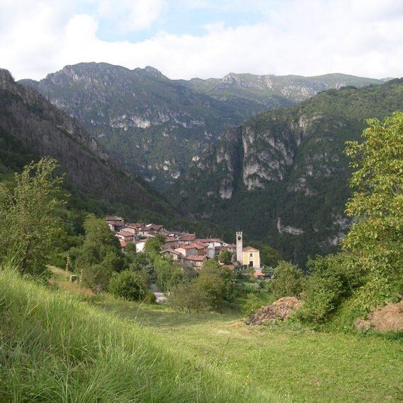
Molino di Bollone (510 m), where it is possible to park, is located in the immediate vicinity of Lake Valvestino. The itinerary begins a few dozen metres from the bar (+39.338.4059036) in the direction of Gargnano, after having crossed the bridge. At the end of the bridge, turn left onto a dirt road with wooden signs for Droane-S.Vigilio-Camiolo. Stay on the forest road for 500 metres, climbing the slope with a few bends until you reach a crossroads. Here you turn right following path no. 264, formerly 54; by continuing straight on, it is possible to reach Tavagnone. Continue uphill on a stretch of dirt road and then continue on the level when the road becomes a path. Along the way, it is possible to sight several splendid floral species and beautiful rocks; in the distance, among the trees, you can see Borgo Bollone. After about forty minutes from the start of the hike, the route offers a spectacular view of Lake Valvestino. Following a sharp curve to the left, close to the viewpoint, the path becomes narrower (some sections are very narrow and therefore require a firm foot and attention). Proceeding, you arrive at some abandoned farmsteads in the Martelletto locality (707 m), where there is also a small pool. From here, it takes about 40 minutes of waling to reach the buildings of Droane (875 m) and the path crosses a small stream and climbs until you merge onto a dirt road, on which you turn left. At the following crossroad, turn right and in a few minutes you will reach the little church of San Vigilio (808 m); a cross in memory of the plague is located on the back.
Nearby, there is a curious building obtained in a ravine called “cùel”, which was inhabited until 1952.
In an unspecified year between 1496 and 1537, a violent epidemic of plague spread through the village of Droane, killing its population of around 150 inhabitants. The plague was so terrible that, placing a loaf at the Croce di Camiolo, between Droane and Val Vestino, the part of the loaf facing the village of Droane turned black and rotted, while the other remained white.
The only survivors were two old women who, having taken refuge in a stable, were immune to the infection thanks to the smell of the goat “bec”. Finding themselves alone, the two women sought hospitality elsewhere. One died on the way, while the other arrived in Tignale, where she found hospitality. When she died, she bequeathed the land she owned near Droane, subordinating the bequest to the observance of a condition: that every year on St. Vigil’s Day a Mass should be celebrated and a quintal of bread should be distributed among the participants.
Return to the crossroads between the meadows and continue along the road which, after 200 metres, bends to the left and points towards the fir forest in the direction of Dos di Sas. In a few minutes you reach a building in the locality of Pavarì (875 m) where you follow, on the left, path n. 264 (formerly 54) again; we will pay attention to the terrain so as not to lose sight of the trace of the path to follow. After this short stretch, when the path forks, to the right it leads to Bocca alla Croce, we continue to the left and thus reach a building in the locality of Tavagnone (964 m) from where a wonderful panorama opens up as we can admire all the towns the municipality of Valvestino: from the left Bollone, Moerna, Persone, Turano below and Armo.
In the background is Monte Càrzen, M. Manòs, M. Stino with Capovalle, Bocca Cocca, M. Cingla, Bocca di Valle and M. Cortina. Follow the road downhill to the start of the route taken on the outward journey and return to Molino di Bollone (510 m), the starting point.
Alternatively, from Droane, it is possible to descend into the Droanello Valley in half an hour and then, in about 40 minutes, rejoin to the locality of Lignago, with the asphalt provincial road that runs alongside Lake Valvestino, where there is a plaque indicating the position of the old border between Italy and Austro-Hungary. Through this road we will return to Molino di Bollone in about 20 minutes.

1. Droane, the charming little church of San Vigilio.

2. The beginning of the route, a few dozen metres from the bar towards Gargnano, after having crossed the bridge at the end of which you turn left onto a dirt road.

3. Signpost at the beginning of the itinerary.

4. The junction for Martelletto/Droane/Camiolo and loc. Tavagnone where you turn right.

5. The dirt road at the junction for Martelletto/Droane/Camiolo and the Tavagnone locality.

6. Wonderful floral species along the way.

6 bis. Wonderful floral species along the way.

7. Rocks along the path.

8. The spectacular view of Lake Valvestino from the panoramic pulpit.
More contents
Bike and Trekking


Visit Val Vestino
Interactive experience, available for free for your iPhone and Android device